
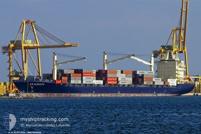
ELIZABETH
Container Ship
Current Trip
| Time Travelled | 12 days |
|---|---|
| Remaining Time | --- |
| Distance Travelled | 1519.81 nm |
| Remaining Distance | --- |
| AVG Speed | 10 Knots |
| MAX Speed | 11.8 Knots |
| AVG Wind | 9.3 knots |
| MAX Wind | 18 knots |
| MIN Temp | 23.5°C / 74.3°F |
| MAX Temp | 28.8°C / 83.84°F |
| Draught | 11.6 m |
| Position Received | 2024-04-29 07:01 |
Current Position
| Longitude | -17.98045° |
|---|---|
| Latitude | 16.01267° |
| Status | Under way using engine |
| Speed | 17.7 Knots |
| Course | 179.2° |
| Area | North Atlantic Ocean |
| Station | T-AIS |
| Position Received | 2024-04-29 07:01 |
Info
Information
The current position of ELIZABETH is in North Atlantic Ocean with coordinates 16.01267° / -17.98045° as reported on 2024-04-29 07:01 by AIS to our vessel tracker app. The vessel's current speed is 17.7 Knots and is heading at the port of ALGECIRAS.
The vessel ELIZABETH (IMO: 9246346, MMSI: 636020454) is a Container Ship that was built in 2003 ( 21 years old ). It's sailing under the flag of [LR] Liberia.
In this page you can find informations about the vessels current position, last detected port calls, and current voyage information. If the vessels is not in coverage by AIS you will find the latest position.
The current position of ELIZABETH is detected by our AIS receivers and we are not responsible for the reliability of the data. The last position was recorded while the vessel was in Coverage by the Ais receivers of our vessel tracking app.
The current draught of ELIZABETH as reported by AIS is 11.6 meters
Weather
| Temperature | 27.8°C / 82.04°F |
|---|---|
| Wind Speed | 10 knots |
| Direction | 199° SSW |
| Pressure | 1012.1 hPa |
| Humidity | 78.2 % |
| Cloud Coverage | 80 % |
Featured Company
Most Visited Ports (Last year)
| Port | Arrivals | |
|---|---|---|
| 11 | ||
| 9 | ||
| 9 | ||
| 2 | ||
| 2 | ||
| 2 |
Last Trips
| Origin | Departure | Destination | Arrival | Distance | |
|---|---|---|---|---|---|
| 2024-05-04 08:13 | 2024-05-20 07:34 | 2596.15 nm | |||
| 2024-04-23 15:18 | 2024-05-02 13:04 | 2140.02 nm | |||
| 2024-04-17 23:03 | 2024-04-22 21:48 | 1662.64 nm | |||
| 2024-04-10 08:00 | 2024-04-15 22:49 | 1582.40 nm | |||
| 2024-03-27 19:53 | 2024-04-09 19:16 | 847.60 nm |
Events
| Time | Event | Details | Position / Dest | Info |
|---|---|---|---|---|
| 2024-05-31 13:38 | STOP Moving | 6.74 nm, South East of TEMA |
5.54021 / .08293
ESALG
|
Speed: 0.3 kn Course: 239° |
| 2024-05-30 23:50 | START Moving |
4.18461 / -1.40569
ESALG
|
Speed: 5.5 kn Course: 12° |
|
| 2024-05-30 19:46 | STOP Moving |
4.12881 / -1.45124
ESALG
|
Speed: 0.3 kn Course: 256° |
|
| 2024-05-30 10:11 | START Moving |
4.08167 / -1.92333
ESALG
|
Speed: 5 kn Course: 102° |
|
| 2024-05-30 06:23 | STOP Moving |
4.04833 / -1.97167
ESALG
|
Speed: Course: -1° |
|
| 2024-05-29 19:23 | START Moving |
4.07302 / -3.93897
ESALG
|
Speed: 9.8 kn Course: 124° |
|
| 2024-05-29 06:50 | STOP Moving |
4.10833 / -4.13667
ESALG
|
Speed: Course: -1° |
|
| 2024-05-28 19:38 | START Moving |
4.17333 / -6.13833
ESALG
|
Speed: 8 kn Course: 148° |
|
| 2024-05-28 06:43 | STOP Moving |
4.03141 / -6.31309
ESALG
|
Speed: 0.2 kn Course: 214° |
|
| 2024-05-27 19:11 | START Moving |
4.30167 / -8.37333
ESALG
|
Speed: 4 kn Course: -1° |