
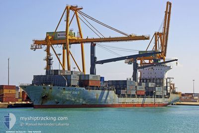
KONRAD
Container Ship
Current Trip
| Time Travelled | 8 days |
|---|---|
| Remaining Time | 1 day |
| Distance Travelled | 2923.45 nm |
| Remaining Distance | 367.36 nm |
| AVG Speed | 14.1 Knots |
| MAX Speed | 18 Knots |
| AVG Wind | 9.3 knots |
| MAX Wind | 18 knots |
| MIN Temp | 27.8°C / 82.04°F |
| MAX Temp | 32.7°C / 90.86°F |
| Draught | 11.3 m |
| Position Received | 11 h, 44 m ago |
Current Position
| Longitude | 37.37998° |
|---|---|
| Latitude | 22.56890° |
| Status | Under way using engine |
| Speed | 13.8 Knots |
| Course | 336.4° |
| Area | Red Sea |
| Station | T-AIS |
| Position Received | 11 h, 44 m ago |
Info
Information
The current position of KONRAD is in Red Sea with coordinates 22.56890° / 37.37998° as reported on 2024-06-16 12:07 by AIS to our vessel tracker app. The vessel's current speed is 13.8 Knots and is heading at the port of SUEZ CANAL. The estimated time of arrival as calculated by vessel tracking app is 2024-06-18 01:19 LT
The vessel KONRAD (IMO: 9292125, MMSI: 636020910) is a Container Ship that was built in 2005 ( 19 years old ). It's sailing under the flag of [LR] Liberia.
In this page you can find informations about the vessels current position, last detected port calls, and current voyage information. If the vessels is not in coverage by AIS you will find the latest position.
The current position of KONRAD is detected by our AIS receivers and we are not responsible for the reliability of the data. The last position was recorded while the vessel was in Coverage by the Ais receivers of our vessel tracking app.
The current draught of KONRAD as reported by AIS is 11.3 meters
Weather
| Temperature | 28.7°C / 83.66°F |
|---|---|
| Wind Speed | 14 knots |
| Direction | 296° WNW |
| Pressure | 1003.6 hPa |
| Humidity | 80.2 % |
| Cloud Coverage | --- |
Featured Company
Last Port Calls
| Port | Arrival | Departure | Time In Port |
|---|---|---|---|
| 2024-06-07 18:25 | 2024-06-08 09:17 | 14 h | |
| 2024-06-04 06:43 | 2024-06-04 13:47 | 7 h | |
| 2024-05-20 03:28 | 2024-05-20 11:13 | 7 h | |
| 2024-05-15 17:04 | 2024-05-16 04:28 | 11 h | |
| 2024-05-13 03:16 | 2024-05-13 15:52 | 12 h | |
| 2024-04-26 09:20 | 2024-04-27 03:20 | 18 h | |
| 2024-04-24 15:14 | 2024-04-25 02:31 | 11 h | |
| 2024-04-16 03:27 | 2024-04-16 12:17 | 8 h | |
| 2024-04-12 05:05 | 2024-04-13 08:22 | 1 d | |
| 2024-04-10 14:20 | 2024-04-11 00:58 | 10 h |
Most Visited Ports (Last year)
| Port | Arrivals | |
|---|---|---|
| 10 | ||
| 10 | ||
| 8 | ||
| 5 | ||
| 5 | ||
| 5 |
Last Trips
| Origin | Departure | Destination | Arrival | Distance | |
|---|---|---|---|---|---|
| 2024-06-04 19:17 | 2024-06-07 23:55 | 392.70 nm | |||
| 2024-05-20 19:13 | 2024-06-04 12:13 | 4281.36 nm | |||
| 2024-05-16 12:28 | 2024-05-20 11:28 | 1101.42 nm | |||
| 2024-05-13 23:52 | 2024-05-16 01:04 | 485.87 nm | |||
| 2024-04-27 08:50 | 2024-05-13 11:16 | 5015.36 nm | |||
| 2024-04-25 08:01 | 2024-04-26 14:50 | 425.16 nm | |||
| 2024-04-13 11:22 | 2024-04-24 20:44 | 3823.67 nm | |||
| 2024-04-13 11:22 | 2024-04-16 05:27 | 803.73 nm | |||
| 2024-04-11 03:58 | 2024-04-12 08:05 | 58.01 nm | |||
| 2024-04-10 06:35 | 2024-04-10 17:20 | 62.80 nm |
Events
| Time | Event | Details | Position / Dest | Info |
|---|---|---|---|---|
| 2024-06-16 12:10 | Status Changed | Default Under way using engine |
22.58010 / 37.37471
SUEZ
|
Speed: 13.8 kn Course: 336.4° |
| 2024-06-16 12:07 | OUT of Coverage |
22.56890 / 37.37998
Red Sea
SUEZ
|
Speed: 13.8 kn Course: 336.4° |
|
| 2024-06-16 11:11 | Status Changed | Under way using engine Default |
22.37139 / 37.47000
SUEZ
|
Speed: 13.5 kn Course: 335° |
| 2024-06-16 10:59 | Status Changed | Default Under way using engine |
22.33075 / 37.49031
SUEZ
|
Speed: 13.6 kn Course: 331.5° |
| 2024-06-16 10:48 | Status Changed | Under way using engine Default |
22.29499 / 37.51100
SUEZ
|
Speed: 13.4 kn Course: 328° |
| 2024-06-16 10:03 | Status Changed | Default Under way using engine |
22.14590 / 37.60387
SUEZ
|
Speed: 13.5 kn Course: 331° |
| 2024-06-16 09:48 | Status Changed | Under way using engine Default |
22.09913 / 37.63144
SUEZ
|
Speed: 13.3 kn Course: 331° |
| 2024-06-16 09:30 | Status Changed | Default Under way using engine |
22.03952 / 37.66551
SUEZ
|
Speed: 13.5 kn Course: 333.5° |
| 2024-06-16 09:12 | Change Sea Area | Disputed Sudan-Egypt part of the Red Sea Sudanese part of the Red Sea |
21.97761 / 37.69780
Red Sea
SUEZ
|
Speed: 13.5 kn Course: 334.8° |
| 2024-06-16 09:12 | Status Changed | Under way using engine Default |
21.97761 / 37.69780
SUEZ
|
Speed: 13.4 kn Course: 334° |