
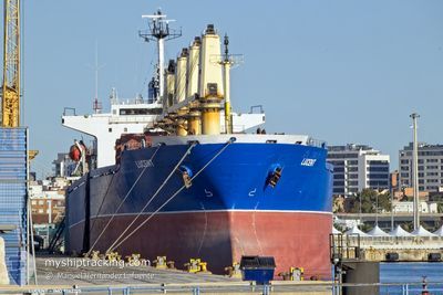
LUCENT
Bulk Carrier
Current Trip
| Time Travelled | 26 days |
|---|---|
| Remaining Time | --- |
| Distance Travelled | 1385.47 nm |
| Remaining Distance | --- |
| AVG Speed | 9.7 Knots |
| MAX Speed | 9.7 Knots |
| AVG Wind | 9.2 knots |
| MAX Wind | 26.1 knots |
| MIN Temp | 13.3°C / 55.94°F |
| MAX Temp | 31.6°C / 88.88°F |
| Draught | 9.6 m |
| Position Received | Now |
Current Position
| Longitude | 35.49626° |
|---|---|
| Latitude | 34.48238° |
| Status | Not under command |
| Speed | 3.8 Knots |
| Course | 241° |
| Area | Mediterranean Sea - Eastern Basin |
| Station | T-AIS |
| Position Received | Now |
Info
Information
The current position of LUCENT is in Mediterranean Sea - Eastern Basin with coordinates 34.48238° / 35.49626° as reported on 2024-06-16 14:49 by AIS to our vessel tracker app. The vessel's current speed is 3.8 Knots and is heading at the port of TRIPOLI. The estimated time of arrival as calculated by vessel tracking app is 2024-06-13 15:00 LT
The vessel LUCENT (IMO: 9142215, MMSI: 370234000) is a Bulk Carrier that was built in 1997 ( 27 years old ). It's sailing under the flag of [PA] Panama.
In this page you can find informations about the vessels current position, last detected port calls, and current voyage information. If the vessels is not in coverage by AIS you will find the latest position.
The current position of LUCENT is detected by our AIS receivers and we are not responsible for the reliability of the data. The last position was recorded while the vessel was in Coverage by the Ais receivers of our vessel tracking app.
The current draught of LUCENT as reported by AIS is 9.6 meters
Weather
| Temperature | 26.2°C / 79.16°F |
|---|---|
| Wind Speed | 14 knots |
| Direction | 224° SW |
| Pressure | 1007.9 hPa |
| Humidity | 75.2 % |
| Cloud Coverage | --- |
Featured Company
Last Port Calls
| Port | Arrival | Departure | Time In Port |
|---|---|---|---|
| 2024-05-21 13:22 | 2024-05-21 14:39 | 1 h | |
| 2024-05-13 14:42 | 2024-05-15 15:04 | 2 d | |
| 2024-04-09 04:41 | 2024-04-09 13:37 | 8 h |
Most Visited Ports (Last year)
| Port | Arrivals | |
|---|---|---|
| 8 | ||
| 3 | ||
| 2 | ||
| 2 | ||
| 1 | ||
| 1 |
Last Trips
| Origin | Departure | Destination | Arrival | Distance | |
|---|---|---|---|---|---|
| 2024-05-15 18:04 | 2024-05-21 16:22 | 488.58 nm | |||
| 2024-03-31 18:05 | 2024-05-13 17:42 | 3579.82 nm | |||
| 2024-03-31 18:05 | 2024-04-09 06:41 | 1232.98 nm |
Events
| Time | Event | Details | Position / Dest | Info |
|---|---|---|---|---|
| 2024-06-16 12:58 | START Moving | 14.05 nm, North West of SELAATA |
34.45654 / 35.46221
LB KYE
|
Speed: 5.5 kn Course: 225.8° |
| 2024-06-16 09:11 | Status Changed | Not under command Default |
34.41098 / 35.41614
LB KYE
|
Speed: 0.3 kn Course: 302° |
| 2024-06-16 08:59 | Status Changed | Default Not under command |
34.41058 / 35.41487
LB KYE
|
Speed: 0.3 kn Course: 303° |
| 2024-06-16 08:02 | Status Changed | Not under command Default |
34.41076 / 35.40783
LB KYE
|
Speed: 0.3 kn Course: 297° |
| 2024-06-16 07:56 | Status Changed | Default Not under command |
34.41100 / 35.40710
LB KYE
|
Speed: 0.3 kn Course: 298° |
| 2024-06-16 07:50 | STOP Moving | 14.42 nm, North West of SELAATA |
34.41117 / 35.40637
LB KYE
|
Speed: 0.3 kn Course: 300° |
| 2024-06-16 03:57 | START Moving | 17.58 nm, North West of SELAATA |
34.45260 / 35.36337
LB KYE
|
Speed: 3.8 kn Course: 338° |
| 2024-06-16 02:43 | Status Changed | Not under command Default |
34.46994 / 35.33716
LB KYE
|
Speed: 1.4 kn Course: 347° |
| 2024-06-16 02:40 | Status Changed | Default Not under command |
34.47058 / 35.33592
LB KYE
|
Speed: 1.5 kn Course: 348° |
| 2024-06-16 02:10 | Status Changed | Not under command Default |
34.47719 / 35.32309
LB KYE
|
Speed: 1.4 kn Course: 353° |